Showing 8054 items matching plenty road
-
 Greensborough Historical Society
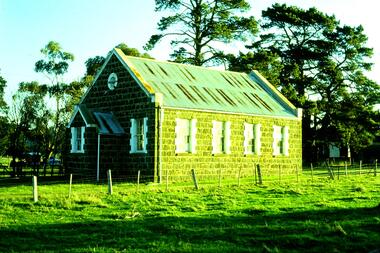
Slide - Photograph, John Ramsdale, Bluestone Church on Plenty Road Mill Park: Slide 30, 1990s
... Bluestone Church on Plenty Road Mill Park: Slide 30...plenty road mill park...Photograph shows a bluestone church on Plenty Road Mill...Photograph Slide Bluestone Church on Plenty Road Mill Park ...Photograph shows a bluestone church on Plenty Road Mill Park.Part of the John Ramsdale collection of slides and audio visual material.Colour photograph scanned from slide.No maker's marks. No caption on slide.plenty road mill park, bluestone church -
 Greensborough Historical Society
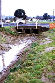
Slide - Photograph, John Ramsdale, Near Plenty Road South Morang: Slide 53, 1990s
... Near Plenty Road South Morang: Slide 53...plenty road south morang...Photograph shows drain and culvert near Plenty Road South...Photograph Slide Near Plenty Road South Morang: Slide 53 ...Photograph shows drain and culvert near Plenty Road South Morang.Part of the John Ramsdale collection of slides and audio visual material.Colour photograph scanned from slide.No maker's marks. No caption on slide.plenty road south morang -
 Whittlesea Historical Society Inc.
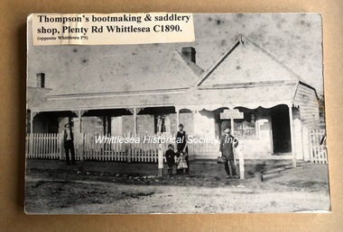
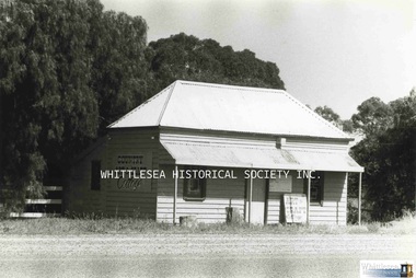
Photograph, Thompson's bootmaking and saddlery shop, Plenty Road, Whittlesea, c.1890
... Thompson's bootmaking and saddlery shop, Plenty Road...plenty road...]. Inscribed in pencil on back of photo [Shops Plenty road Whittlesea... shop, Plenty Road, Whittlesea, c.1890 Black and white print ...This photograph forms part of a collection of photographs gathered by the Whittlesea Historical Society for their project book, "Historic Views of the City of Whittlesea" by Robert Wuchatsch and Gwen Hawke, as part of Australia's Bicentennial Celebrations in 1988. The collection contains over 200 historic photographs covering all aspects of early life in the area now embraced by the City of Whittlesea.Black and white print mounted on a foam backing for display.Adhesive label on front of photo [Thompson's bootmaking & saddlery shop, Plenty Rd, Whittlesea C1890 (opposite Whittlesea PS]. Inscribed in pencil on back of photo [Shops Plenty road Whittlesea opposite Primary School]historic views of the city of whittlesea, thompson family, plenty road, bootmaker, saddlery, whittlesea shop -
 Greensborough Historical Society
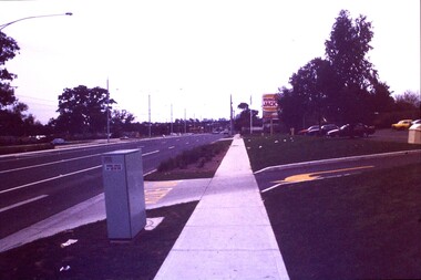
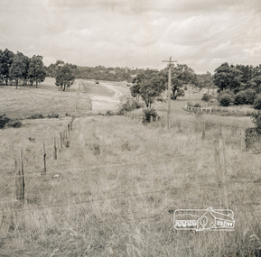
Slide - Photograph, John Ramsdale, Plenty Road: Slide 13, 1990s
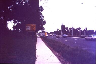
... Plenty Road: Slide 13...plenty road bundoora... - Plenty Road Bundoora....Photograph Slide Plenty Road: Slide 13 Colour photograph ...Photograph shows a 3 lane road with Hungry Jacks sign - Plenty Road Bundoora.Part of the John Ramsdale collection of slides and audio visual material.Colour photograph scanned from slide.No maker's marks. No caption on slide.plenty road bundoora -
 Greensborough Historical Society
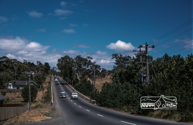
Slide - Photograph, John Ramsdale, Plenty Road near Parade College: Slide 29, 1990s
... Plenty Road near Parade College: Slide 29...plenty road bundoora... This is Plenty Road Bundoora, near Parade college....Photograph Slide Plenty Road near Parade College: Slide 29 ...Photograph shows a 3-lane road with "Federally funded" sign This is Plenty Road Bundoora, near Parade college.Part of the John Ramsdale collection of slides and audio visual material.Colour photograph scanned from slide.No caption. Printed maker's mark on slide "Kodak Kodachrome Slide"plenty road bundoora, parade college -
 Greensborough Historical Society
Slide - Photograph, John Ramsdale, Plenty Road and urban creep: Slide 28, 1990s
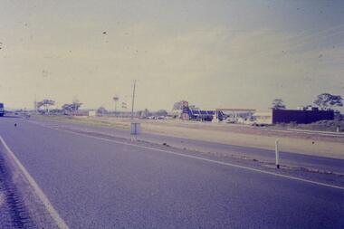
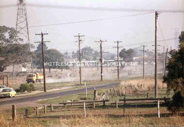
... Plenty Road and urban creep: Slide 28...plenty road mill park...Photograph shows Plenty Road Mill Park with Shell petrol...Photograph Slide Plenty Road and urban creep: Slide 28 ...Photograph shows Plenty Road Mill Park with Shell petrol station and Macdonalds, showing the urban expansion in this area.Part of the John Ramsdale collection of slides and audio visual material.Colour photograph scanned from slide.No maker's marks. No caption on slide.plenty road mill park, urbanisation -
 Whittlesea Historical Society Inc.
Photograph, Miss Janet Gordon's Cottage, Plenty Road, South Morang, 1985
... Miss Janet Gordon's Cottage, Plenty Road, South Morang...plenty road south morang...Miss Janet Gordon's cottage on the corner of Plenty Road.... Miss Janet Gordon's cottage on the corner of Plenty Road ...Miss Janet Gordon's cottage on the corner of Plenty Road at South Morang. In the 1980s, Mrs. L. Dynon leased the house and opened her shop "Charlotte's Web" there. She would advertise and hold spinning demonstrations, have art and craft work on display and for sale, as well as fleece. The building was destroyed by fire in the 1990's.Photograph print, also digital image on HD.south morang, janet gordon, gordon family, charlotte's web south morang, plenty road south morang, art craft shop, plenty road shop -
 Melbourne Tram Museum
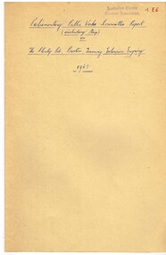
Document, Victorian Parliament, "The Plenty Road, Preston, Tramway Extension Inquiry", 1967
... "The Plenty Road, Preston, Tramway Extension Inquiry"...Plenty Road... Committee on "The Plenty Road, Preston, Tramway Extension Inquiry... on "The Plenty Road, Preston, Tramway Extension Inquiry" - 1967 ...Report by the Victorian Parliamentary Public Works Committee on "The Plenty Road, Preston, Tramway Extension Inquiry" - 1967. The inquiry examined the MMTB's proposal to extend the East Preston line 0.7miles or 1.3km. The Committee took evidence from the MMTB, bus operators, the Victorian Railways, residents, La Trobe University, Preston City Council and others. The Committee recommended against the proposal. The report lists those members of Parliament involved. The line was subsequently extended by 1.2 kilometres from Tyler Street to Boldrewood Parade during 1983 and subsequently to Bundoora. Demonstrates the method of holding parliamentary inquiries into new tram lines.Document - report - 9 pages stapled in top left-hand corner, printed with a spirit duplicator.tramways, parliament, new lines, east preston, inquiries, bundoora, plenty road -
 Eltham District Historical Society Inc
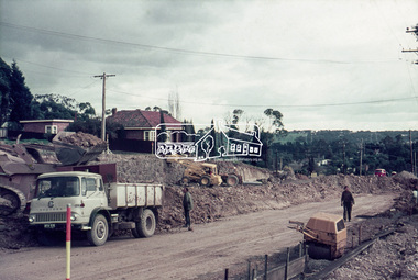
Photograph, Looking east from the northern side of Lower Plenty Road (opposite Bannockburn Road) as it crosses the Watsonia Drain, Viewbank, c.1965, 1965c
... Looking east from the northern side of Lower Plenty Road... roadworks for the re-alignment of Lower Plenty Road for the new... Plenty Road (opposite Bannockburn Road) as it crosses ...Transmission power lines visible in distance behind the Lower Plenty Hotel (in centre upper) and parts of Heidelberg Golf Club. In the foreground a bulldozer can be seen commencing roadworks for the re-alignment of Lower Plenty Road for the new Lower Plenty Bridge crossing.Medium format 120 6x6 black and white negative film, 1 frameheidelberg golf club, lower plenty, lower plenty hotel, road construction, viewbank, watsonia drain -
 Whittlesea Historical Society Inc.
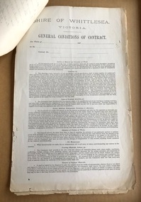
Document - Contract, Contract No.7, Shire of Whittlesea, Victoria. Plenty Main Road, 10 Dec 1888
... Contract No.7, Shire of Whittlesea, Victoria. Plenty Main...main plenty road... on the side of the Main Plenty Road, between Yan Yean Road... of Whittlesea, Victoria. Plenty Main Road. 3 sheets of paper held ...Specifications for supplying 300 Cubic Yards of Metal on the side of the Main Plenty Road, between Yan Yean Road and the Plenty River Bridge, Whittlesea.3 sheets of paper held together with a brass split pin, includes General Conditions of ContractContract signed by William Henry Lockwood, Engineer, with Bryan McSweeney. Dated 10 December 1888.contract, william lockwood, main plenty road, whittlesea, yan yean road, bryan mcsweeney -
 Eltham District Historical Society Inc
Photograph, Fred Mitchell, Lower Plenty Road, Yallambie, 1968
... Lower Plenty Road, Yallambie, 1968...Lower Plenty Road... melbourne Photograph Lower Plenty Road, Yallambie, 1968 Digital copy ...Road to Rosanna beside Watsonia Army Barracks. Immediately to left is Broadlea Crescent.Digital copy of colour photographfred mitchell collection, 1968, broadlea crescent, lower plenty road, watsonia barracks, yallambie -
 Greensborough Historical Society
Map, Melbourne and Metropolitan Board of Works. Survey Division, MMBW, Yarra 2500 / 11.21. Bundoora, east of Plenty Road, 1979_01
... MMBW, Yarra 2500 / 11.21. Bundoora, east of Plenty Road.... map] 11-21. Bundoora, east of Plenty Road. Parish.... Bundoora, east of Plenty Road. MMBW Map in 1:2500 [scale] series ...Melbourne and Metropolitan Board of Works. Yarra 2500 [base map] 11-21. Bundoora, east of Plenty Road. Parish of Keelbundoora 2856, Municipalities of Diamond Valley 257, Preston 225 and Whittlesea 239. Prominent streets include: Grimshaw Street, Settlement Road and Plenty Road. Includes Yulong Park.MMBW Map in 1:2500 [scale] series. Cream parchment with green tape reinforcing on edges and punched holes on left edge.mmbw, melbourne and metropolitan board of works, shire of diamond valley, bundoora - maps -
 Greensborough Historical Society
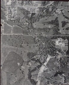
Aerial Photograph, Banyule Road / Lower Plenty Road, 1972c
... Banyule Road / Lower Plenty Road... Plenty Road and Banyule Road... Plenty Lower Plenty melbourne Aerial Photograph Banyule Road ...Viewbank, Rosanna and Lower Plenty area, showing Lower Plenty Road and Banyule RoadAerial survey photograph, black and whiteviewbank -
 Whittlesea Historical Society Inc.
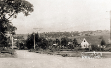
Photograph, Kevin Doyle, South Morang, 1984
... old plenty road south morang...Looking at Plenty Road from Old Plenty Road. Pub and shops... at Plenty Road from Old Plenty Road. Pub and shops in background c ...One of a series of photographs taken and developed during 1967-2013 by the late Kevin Doyle for Media Studies Year 12 at Parade College Bundoora (1984) and donated to the Society by his mother Maureen Doyle.PhotographLooking at Plenty Road from Old Plenty Road. Pub and shops in background c.1984.kevin doyle collection, south morang, old plenty road south morang, plenty road south morang -
 Melbourne Tram Museum
Slide, Keith Kings, 17/04/1968 12:00:00 AM
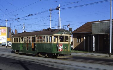
... Plenty Road... of W2 642 leaving or shunting at East Preston Depot, Plenty Road... of exposure. "MMTB W2 642, Plenty Road East Preston Depot - vent roof... Trams tramways W2 class East Preston Depot Plenty Road Route 11 ...35mm Kodak white cardboard colour slide by Keith Kings of W2 642 leaving or shunting at East Preston Depot, Plenty Road. has the destination of East Preston Bell St, route 11 and a advert for Reddi. Photo 17/4/1968. See Inscription for a note re the roof.Keith Kings stamp and number "22-3", with details of exposure. "MMTB W2 642, Plenty Road East Preston Depot - vent roof and drip rails. 17/4/1968trams, tramways, w2 class, east preston depot, plenty road, route 11, tram 642 -
 Melbourne Tram Museum
Document - Report, Parliamentary Public Works Committee, "Parliamentary Public Works Committee Report Plenty Road, Preston, Tramway Extension Enquiry, 1967
... "Parliamentary Public Works Committee Report Plenty Road... Committee Report (including map) on The Plenty Road, Preston... Committee Report (including map) on The Plenty Road, Preston ...Report contained within a light brown card folder, containing a photocopy of report titled "Parliamentary Public Works Committee Report (including map) on The Plenty Road, Preston, Tramway Extension Enquiry - 1967". Report stapled in top right hand corner, 15 pages examining the extension of the East Preston route to Bolderwood Parade. Map shows extension proposed, bus routes, railway lines, streets - folded into 4.AETA stamp on front and inside sheet and "4E6" in ink on front cover. AETA stamp on the bottom right hand corner of the map.trams, tramways, east preston, new tramway, bolderwood parade, proposals -
 Whittlesea Historical Society Inc.
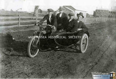
Photograph, Jeff Sole, A ride down Plenty Road, South Morang
... A ride down Plenty Road, South Morang... with a sidecar on Plenty Road at South Morang, with the Commercial Hotel... Whittlesea melbourne Photograph A ride down Plenty Road, South Morang ...Driver Charlie Junor and three men on a motorcycle with a sidecar on Plenty Road at South Morang, with the Commercial Hotel in the background. One of a series of photographs from the Jeff Sole Family Photograph Collection. Photocopy of a black and white print also digital imageFrom Jeff Sole Collectionsouth morang, charlie junor, junor family, sole family, jeff sole collection, commercial hotel south morang, motorcycle sidecar -
 Eltham District Historical Society Inc
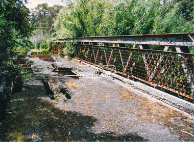
Negative - Photograph, J.A. McDonald, Eltham-Yarra Glen Road, Lower Plenty footbridge, Sep. 1955
... Eltham-Yarra Glen Road, Lower Plenty footbridge...Lower Plenty Road... the Plenty River is now known as Lower Plenty Road which becomes Main... melbourne Photograph Negative Eltham-Yarra Glen Road, Lower Plenty ...The Eltham-Yarra Glen Road as designated originated at the Shire of Eltham boundary at the Plenty River. West of the river the road was known as the Heidelberg-Eltham Road. The section from the Plenty River is now known as Lower Plenty Road which becomes Main Road. The footbridge no longer exists but was originally sited to the south, adjacent to the old Lower Plenty Bridge, now part of the Plenty River Trail. Record of various Shire of Eltham infrastructure works undertaken during the period of 1952-1962 involving bridge and road reconstruction projects, sometimes with Eltham Shire Council Project Reference numbers quoted. It was during this period that a number of significant improvements were made to roads and new bridges constructed within the shire that remain in place as of present day (2022). In many situations, the photos provide a tangible visible record of infrastructure that existed throughout the early days of the Shire. The album was put together by or under the direction of the Shire Engineer, J.A. McDonald.1955-09, eltham-yarra glen road, lower plenty footbridge, lower plenty, lower plenty bridge, lower plenty road, main road, plenty river trail, bridge construction, infrastructure, shire of eltham -
 Eltham District Historical Society Inc
Negative - Photograph, J.A. McDonald, Eltham-Yarra Glen Road, Lower Plenty footbridge, Sep. 1955
... Eltham-Yarra Glen Road, Lower Plenty footbridge...Lower Plenty Road...-Eltham Road. The section from the Plenty River is now known... melbourne Photograph Negative Eltham-Yarra Glen Road, Lower Plenty ...Tony Carberry and J. Jolly The Eltham-Yarra Glen Road as designated originated at the Shire of Eltham boundary at the Plenty River. West of the river the road was known as the Heidelberg-Eltham Road. The section from the Plenty River is now known as Lower Plenty Road which becomes Main Road. The footbridge no longer exists but was originally sited to the south, adjacent to the old Lower Plenty Bridge, now part of the Plenty River Trail. Record of various Shire of Eltham infrastructure works undertaken during the period of 1952-1962 involving bridge and road reconstruction projects, sometimes with Eltham Shire Council Project Reference numbers quoted. It was during this period that a number of significant improvements were made to roads and new bridges constructed within the shire that remain in place as of present day (2022). In many situations, the photos provide a tangible visible record of infrastructure that existed throughout the early days of the Shire. The album was put together by or under the direction of the Shire Engineer, J.A. McDonald.1955-09, eltham-yarra glen road, lower plenty footbridge, j. jolly, lower plenty, lower plenty bridge, lower plenty road, main road, plenty river trail, tony carberry, bridge construction, infrastructure, shire of eltham -
 Eltham District Historical Society Inc
Slide, Looking southwest across to 184 Main Road, Lower Plenty during road widening works, 20 July 1970, 1970
... Looking southwest across to 184 Main Road, Lower Plenty...duplication, Lower Plenty, Main Road, Road construction...Road works to widen and duplicate Main Road at Lower Plenty... Plenty during road widening works, 20 July 1970 35 mm colour ...Road works to widen and duplicate Main Road at Lower Plenty from top of hill near Grand Boulevard, Montmorency to shire border at Lower Plenty bridge35 mm colour positive transparency Mount - Agfacolor Service (Blue)duplication, lower plenty, main road, road construction -
 Eltham District Historical Society Inc
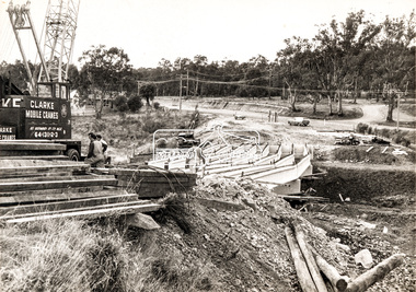
Photograph, Construction of new bridge over the Plenty River, Main Road, Lower Plenty, c.Aug. 1966
... Construction of new bridge over the Plenty River, Main Road...Construction of the Main Road bridge over the Plenty River...Marking on back of photograph - Plenty River Bridge Main... the Plenty River, Main Road, Lower Plenty Black and white print ...Construction of the Main Road bridge over the Plenty River. Includes structural members, construction personnel, vehicles and a Clarke mobile crane.Local significanceBlack and white printMarking on back of photograph - Plenty River Bridge Main Road 1969 (sic)lower plenty, main road, plenty river, bridge, bridge construction, civil engineering, cranes, mobile cranes -
 Eltham District Historical Society Inc
Photograph, Construction of new bridge over the Plenty River, Main Road, Lower Plenty, c.Aug. 1966
... Construction of new bridge over the Plenty River, Main Road...Construction of the Main Road bridge over the Plenty River... the Plenty River, Main Road, Lower Plenty Black and white print ...Construction of the Main Road bridge over the Plenty River. Includes structural members, construction personnel, vehicles and a Clarke mobile crane.Local significanceBlack and white printlower plenty, main road, plenty river, bridge, bridge construction, civil engineering, cranes, mobile cranes -
 Eltham District Historical Society Inc
Photograph, Doug Orford, Bridge across Plenty River, Main Road, Lower Plenty, 1991
... Bridge across Plenty River, Main Road, Lower Plenty, 1991... of Eltham. bridges lower plenty main road plenty river Colour ...From a collection of 35 photos taken by Doug Orford at 35 specific locations along the exact boundary of the then Shire of Eltham.Colour photographbridges, lower plenty, main road, plenty river -
 Whittlesea Historical Society Inc.
Photograph, Evan Meades, Railway Cutting, South Morang, Mar 1989
... Plenty Road..."Railway cutting South Morang Plenty Road March 89"... copy of a photograph "Railway cutting South Morang Plenty Road ...One of a series of photographs taken in 1988-1989 around the Shire of Whittlesea by Evan Meades.Print copy of a photograph"Railway cutting South Morang Plenty Road March 89"evan meades collection, railway cutting, benson's cutting south morang, south morang, plenty road, whittlesea train line route, plenty road south morang -
 Eltham District Historical Society Inc
Negative - Photograph, J.A. McDonald, Eltham-Yarra Glen Road, Lower Plenty, c. July 1962
... Eltham-Yarra Glen Road, Lower Plenty... Hotel. Present-day Lower Plenty Road follows a revised... melbourne Photograph Negative Eltham-Yarra Glen Road, Lower Plenty ...View looking west across the Eltham-Yarra Glen Road approaching the Lower Plenty Bridge near turn-off for the Golf Club Hotel. Present-day Lower Plenty Road follows a revised alignment across a new bridge. The former bridge is now part of the Plenty River Trail and Edward Willis Court now follows this section of the original Eltham-Yarra Glen Road.. The Golf Club Hotel is gone and a new Lower Plenty Hotel was built slightly further up the hill.Record of various Shire of Eltham infrastructure works undertaken during the period of 1952-1962 involving bridge and road reconstruction projects, sometimes with Eltham Shire Council Project Reference numbers quoted. It was during this period that a number of significant improvements were made to roads and new bridges constructed within the shire that remain in place as of present day (2022). In many situations, the photos provide a tangible visible record of infrastructure that existed throughout the early days of the Shire. The album was put together by or under the direction of the Shire Engineer, J.A. McDonald.1962-07, shire of eltham, old eltham road, edward willis court, eltham-yarra glen road, golf club hotel, infrastructure, lower plenty, road construction -
 Whittlesea Historical Society Inc.
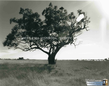
Photograph, Evan Meades, Mill Park Estate, Sep 1988
... Plenty Road..."Mill Park Estate (Nth) from Plenty Road Sept 88"... of a photograph "Mill Park Estate (Nth) from Plenty Road Sept 88" One ...One of a series of photographs taken in 1988-1989 around the Shire of Whittlesea by Evan Meades.Print copy of a photograph"Mill Park Estate (Nth) from Plenty Road Sept 88"evan meades collection, plenty road, mill park, mill park estate, plenty road mill park, red gum tree -
 Eltham District Historical Society Inc
Photograph, Doug Orford, Lower Plenty Bridge, Old Eltham Road, Lower Plenty, 1998
... Lower Plenty Bridge, Old Eltham Road, Lower Plenty... melbourne Photograph Photograph Lower Plenty Bridge, Old Eltham Road ...Originally the boundary between the former Shire of Eltham and the City of Heidelberg, a toll gate existed on the Eltham side. The bridge has since been restored and is now part of the Plenty River Trail.Two colour photograph prints 10 x 15 cm (2 copies)bridges, lower plenty, main road, plenty river, old eltham road -
 Melbourne Tram Museum
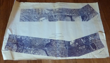
Drawing, Melbourne & Metropolitan Tramways Board (MMTB), Aerial photographs Bundoora Tram Extensions, Plenty Road – MMTB Drawings – 12/1979, Bundoora Extension – Metropolitan Transit Authority – 2/1983, John-Connell – Mott Hay and Anderson – Preliminary drawings for the Latrobe Modal Interchange – August 1984, 1979 to 1984
... Aerial photographs Bundoora Tram Extensions, Plenty Road...Set of drawings for the MMTB Plenty Road extension in 1979... of drawings for the MMTB Plenty Road extension in 1979, MTA extension ...Set of drawings for the MMTB Plenty Road extension in 1979, MTA extension to Bundoora in 1983 and the Latrobe Uni Modal Interchange - 1984. Large print – Aerial photographs Bundoora Tram Extensions Stage 2 – Albert St to Kingsbury Drive Stage 3 – Kingsbury Drive to Settlement Road Has been rolled, left hand edge damaged, right hand edge torn Compiled by the ROW Division – 2/1981. Has written on rear at right hand end “Bundoora Tram Extension – Official MMTB Plans” 760H x 1190W Plenty Road – MMTB Drawings – 12/1979 P15123 Tyler St to Walsal Avenue P15124 Walsal Ave t McColl St P15125 McColl St to Dorrington Avenue Bundoora Extension – Metropolitan Transit Authority – 2/1983 P15400 Dorrington Avenue to Barwon Avenue P15401 Barwon Avenue to Nicholson Ave P15402 Nicholson St to Barling Park P15403 Barling Park to Darebin Creek P15404 Darebin Creek to Scott Grove P15405 Scott Grove to Clunes Street P15406 Clunes St to Cash St P15408 Cash St to Bundoora Park P15409 Bundoora Park to Larundel Hospital P15410 At Larundel Hospital P15411 Larundel Hospital to Marne Court P15412 Marne Court to Cherrywood Court P15413 Cherrywood Court to Morwell Ave P15414 Morwell Ave to Grimshaw St P15415 Grimshaw St to Nickson Street P15416 Nickson St to McLeans Road John-Connell – Mott Hay and Anderson – Preliminary drawings for the Latrobe Modal Interchange – August 1984. 8094-A-20 Set Out Plan and Paving Details 8094-A-21 Elevations 8094-A-22 Sections 8094-A-23 Roof Plan and Stormwater Layout 8094-A-24 Canopy Details 8094-A-25 Toilet Block and Waiting Room 8094-A-28 Miscellaneous DetailsOn rear of aerial photograph sheet - at right hand end “Bundoora Tram Extension – Official MMTB Plans” in felt pen.trams, tramways, plenty rd, bundoora, latrobe university, mmtb, construction, mta -
 Eltham District Historical Society Inc
Photograph, Main Road, Lower Plenty
... Main Road, Lower Plenty...Black and white photograph of Main Road, Lower Plenty... melbourne Photograph Main Road, Lower Plenty Black and white ...Black and white photograph of Main Road, Lower Plenty looking west from Old Eltham Roadlower plenty, main road, old eltham road -
 Greensborough Historical Society
Photograph - Digital Image, Bundoora State School site, Redevelopment sign Bu1915, 01/10/2017
... plenty road bundoora...Plenty Road, Bundoora... state school plenty road bundoora childcare centre Marilyn Smith ...This photograph shows the Auction notice for the redeveloped site, formerly Bundoora State School. The original school building was incorporated into the redevelopment to provide a modern child care facility.Digital copy of colour photographbundoora primary school, bundoora state school, plenty road bundoora, childcare centre